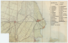
Topografische kaart, horende bij de ligger der wegen in Edam van 1941, geeft overzicht van groot gebied rond Purmerend
Tags
| Download KML |
|
|
Purmerend en omgeving, 1906
Topografische kaart, horende bij de ligger der wegen in Edam van 1941, geeft overzicht van groot gebied rond Purmerend Tags | Download KML | |
 WMS Capabilities URL
 Tiles (Google/OSM scheme)
 Download control points as CSV