Map Warper
Log In
English (en)
Nederlands (nl)
日本語 (ja)
Home
Find Maps by Location
Upload Map
Help
Home
>
Search
>
Maps
>
Map 20
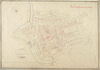
Purmerend 1813
Binnenstad Purmerend, 'Section C de Purmerend en une feuille'
|
Download KML
Share
|
|
Export
Export Links
X
Download KML file
WMS Capabilities URL
Tiles (Google/OSM scheme)
Download control points as CSV
Log in for
More export options
Map Warper
Show
Edit
Rectify
Crop
Align
Preview
Export
Metadata
Activity
Comments (0)
Export
Images
GeoTiff:
Download rectified GeoTiff
PNG:
Download rectified PNG
(and associated .aux.xml file
.aux.xml
)
Map Services
KML:
Download KML file
(for use in Google Earth, etc)
WMS:
WMS Capabilities URL
(
for JOSM OpenStreetMap Editor
)
Tiles (Google/OSM scheme): https://datalab.purmerend.nl/historischekaarten/maps/tile/20?locale=en/{z}/{x}/{y}.png
Biliographic Links:
Biliographic
Ground Control Points
CSV:
Download control points as CSV
 WMS Capabilities URL
 Tiles (Google/OSM scheme)
 Download control points as CSV